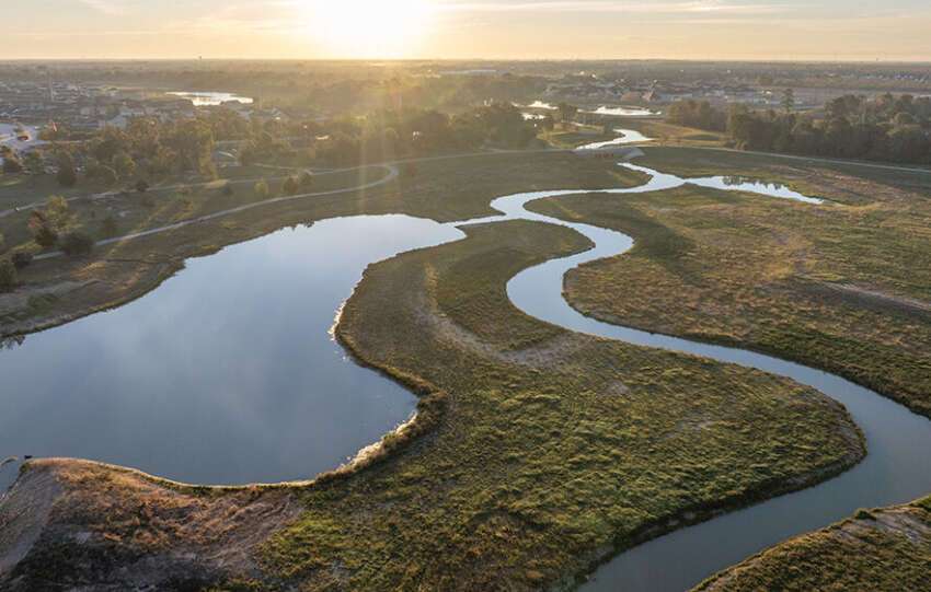
Thanksgiving Day can feature a wide range of weather for the City of Houston and Harris County, from low temperatures below freezing to high temperatures in the upper 80’s, with an average temperature around 60°F.
The coldest temperature recorded on Thanksgiving Day was 23° in 1911 and the hottest was 87° in 1973 at George…
From past floods to future strength, our two-part series explores how Brays Bayou’s story is one of change, resilience, and community progress.
(Read Part 1: Brays Bayou Through the Years: A History of Changes)
In the mid-1980s, the U.S. Army Corps of Engineers conducted watershed studies examining Brays Bayou and surrounding watersheds. Their findings concluded…
Flooding is a major concern for residents of Harris County, and truly understanding flood risk includes learning about how much stormwater our detention basins can hold. The Harris County Flood Control District reports storage capacity in acre-feet, a unit of measurement that helps engineers plan and design flood risk reduction projects.
An acre-foot is a…
From past floods to present progress, this two part series on Brays Bayou’s history highlights more than a century of change, resilience, and ongoing work to reduce flood risk for surrounding communities.
Brays Bayou begins near Mission Bend in northern Fort Bend County and flows east about 31 miles through southwest Harris County before joining…
The Harris County Flood Control District is committed to increasing the efficiency and effectiveness of its drainage infrastructure to better serve the residents of Harris County.
Planting wildflowers is a beneficial practice that promotes native vegetation and beautifies the local landscape. Planting slow-growing wildflowers can delay the first mowing cycle, saving maintenance dollars and allowing…
The Harris County Flood Control District recently wrapped up the first round of listening meetings for the Solutions for Advancing Floodplain Evaluation and Resilience Study (SAFER) Study. These meetings gave residents a chance to share experiences, ask questions, and talk about ideas for reducing the impacts of flooding. The SAFER Study is a major effort…
While every flood risk reduction project is unique, each project typically follows a defined Project Lifecycle, guiding each effort from initial concept to completion and then ultimately into our maintenance program. For the Harris County Flood Control District, the defined Project Lifecycle stages are key to delivering effective flood risk reduction projects. Importantly, throughout…
After a very warm and dry October across Harris County, we’re finally expecting some rain this weekend, which is a welcome change! But what can we expect as we move into November?
Understanding the Big Picture
When we forecast weather patterns for an entire month, we look beyond daily forecasts and short-term models. Instead, we…
On October 15, 1989, as most of the Gulf Coast was easing into fall, Hurricane Jerry made a surprise landfall near Jamaica Beach on Galveston Island. With sustained winds of 85 miles per hour, Jerry wasn’t the strongest storm to hit Texas, but it was one of the latest.
In fact, Jerry was the latest…
Thirty-one years ago this week, relentless rain fell over southeast Texas and changed lives forever. Between October 15 and October 18, 1994, a slow-moving weather system combined with tropical moisture from the Gulf of Mexico and remnants of Hurricane Rosa in the eastern Pacific to unleash catastrophic flooding across southeast Texas, including portions of…
