
Share This Article
The Flood That Built the Flood Control District
The Great Houston Flood of 1935 was the worst flood event in Houston’s history up to that time. An intense 42-hour period of rainfall occurred from December 6 through December 8. While the City of Houston received 5.5 inches of rain, areas to the northwest saw far heavier rainfall totals, with the Humble Oil Company reporting 16.5 inches. It is estimated that a peak of around 20 inches of rain fell in the area northwest of the City of Houston.
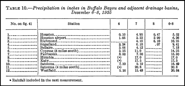
Table 10. – Reported rainfall amounts from the Houston Weather Bureau as shown in the USGS publication “Major Texas Flood of 1935”

Source: U.S. Army Corps of Engineers
The intense rainfall caused catastrophic rises on Buffalo and White Oak bayous.The rushing stormwater drove the water level to 40.3 feet above normal, just below where Buffalo Bayou and White Oak Bayou come together. This was much higher than the 34.3 feet recorded during another major flood on May 3, 1929.
The impact was devastating, leaving Houston’s business district and more than 100 residential blocks underwater. The property loss was estimated at $2.5 million, reflecting extensive damage to roads, bridges, buildings, and their contents. In today’s dollars, that amount equals approximately $55–60 million. This devastation came on the heels of the 1929 flood, and many residents and business owners had only recently finished rebuilding when they were struck again. Tragically, this flood also took the lives of 7 people. The flood shut down the city’s central water plant, leaving Houston without a functioning water supply. It also halted operations at the Port of Houston for months, with docks swallowed by stormwater and the ship channel clogged with silt and debris. Watch historical footage from the Texas Archive of the Moving Image.
On April 23, 1937, prompted by a petition containing striking photographic evidence of repetitive flood destruction, the 45th Texas Legislature unanimously established the Harris County Flood Control District. The subsequent decade saw the construction of the Addicks and Barker reservoirs, on Houston’s western outskirts, designed to help reduce future flooding risks for Downtown Houston.
Historical context and rainfall analysis provided by Meteorologist Lance Wood.
The Flood Control District is continuing to make historic progress in flood risk reduction projects and maintenance efforts thanks to voter support and dedicated staff. Stay informed by following us on social media.