
Share This Article
After a very warm and dry October across Harris County, we’re finally expecting some rain this weekend, which is a welcome change! But what can we expect as we move into November?
Understanding the Big Picture
When we forecast weather patterns for an entire month, we look beyond daily forecasts and short-term models. Instead, we analyze broader climate indicators such as El Niño and La Niña, which are oceanic and atmospheric patterns that influence weather across the globe.
This fall, La Niña conditions have returned. La Niña occurs when below-normal sea surface temperatures develop across the equatorial Pacific Ocean. These cooler waters impact global weather, typically resulting in warmer and drier conditions across the southern United States during the fall and winter months.
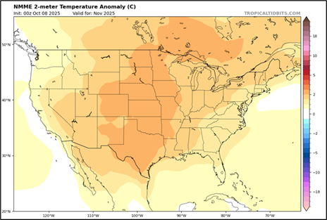
What the Climate Models Are Saying
One of the key tools meteorologists use to assess long-range trends is the North American Multi-Model Ensemble (NMME), a collection of climate models that project temperature and precipitation patterns weeks or even months in advance.
For November, the NMME outlook supports the classic La Niña pattern across the southern U.S.:
- Above-normal temperatures are favored across most of the U.S.
- Below-normal rainfall is likely across much of the central and eastern U.S., including parts of Texas.
What That Means for Harris County
In short, November is shaping up to be warmer and drier than average, continuing the trends we’ve seen this fall. While we may see some short-term rain events, like the one expected this weekend, the overall pattern favors less frequent rainfall and extended warm periods.
November Forecast: Temperature Departure from Normal (NMME):
November Forecast: Precipitation Departure from Normal (NMME):

As always, the Flood Control District team will continue monitoring rainfall patterns and weather forecasts to stay prepared for any changes. Stay informed by following us on social media.